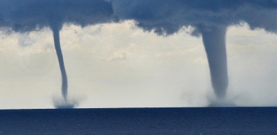
Several more waterspouts whipped up in the sea off Norway’s south coast on Tuesday morning. The sightings came a week after unstable air masses first created the freak weather phenomenon off the Sørlandet coastline.

“Right now I can see three twisters, and a few minutes ago I saw four,” Grimstad resident Just Finnstad told Norwegian Broadcasting (NRK) around 10 o’clock on Tuesday morning. He said the waterspouts or funnel clouds, known as skypumper in Norwegian, were smaller than those reported off the coastal towns of Arendal, Lillesand and Grimstad last Thursday.
Meteorologists warned last week the twisters could be dangerous if they came closer to land. Finnstad said he’d watched the spectacle through his living room window. “I have neighbours who have lived in tornado zones in the USA, and they said that the last waterspouts were large and powerful and could be dangerous,” he said.
While rare, meteorologist Hilde Holdhus at StormGeosier said the phenomenon was likely to become more frequent as climate change caused more summer thunderstorms and rain. “The air will become warmer and more humid,” she told NRK last week. “Then there is a greater chance that we’ll get unstable air with more cumulonimbus clouds. Then it’s likely that we can get more phenomena like this.”
newsinenglish.no staff

